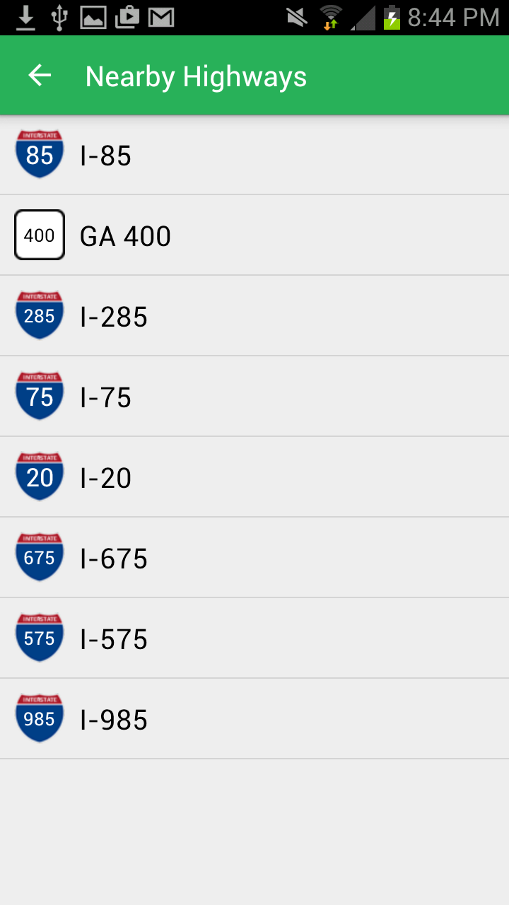
{"metadata":{"image":[],"title":"","description":""},"api":{"url":"/nearby/highways/:latitude/:longitude","auth":"optional","method":"get","params":[{"name":"latitude","type":"double","default":"","desc":"","required":true,"in":"path","ref":"","_id":"560ebbd454af2b0d005bbf89"},{"name":"longitude","type":"double","default":"","desc":"","required":true,"in":"path","ref":"","_id":"560ebbd454af2b0d005bbf88"}],"results":{"codes":[{"status":200,"language":"json","code":"{\n \"highways\": [\n {\n \"id\": 78,\n \"display_name\": \"I-85\",\n \"sign_name\": \"85\",\n \"sign_web_background_image\": \"interstate-bg.svg\",\n \"sign_background_image_small\": \"interstatesign_small.png\",\n \"sign_background_image_large\": \"interstatesign_large.png\",\n \"sign_text_color\": \"#FFFFFF\",\n \"highway_sign_class\": \"interstate-bg\",\n \"highway_type_id\": 1,\n \"highway_type\": \"Interstate\",\n \"positive_direction\": \"North\",\n \"negative_direction\": \"South\",\n \"direction_suffix\": \"bound\",\n \"positive_exit\": {\n \"id\": 28630,\n \"exit_latitude\": \"33.839701\",\n \"exit_longitude\": \"-84.318585\",\n \"destination_latitude\": \"33.839828\",\n \"destination_longitude\": \"-84.314987\",\n \"city\": \"Atlanta\",\n \"state\": \"Georgia\",\n \"postal_code\": \"30329\",\n \"exit_description\": \"US 23 / SR 155 (Clairmont Road)\",\n \"sign_label_line_one\": \"EXIT\",\n \"sign_label_line_two\": \"91\",\n \"sign_number\": \"91\",\n \"formatted_sign_name\": \"Exit 91\",\n \"highway_exit_type_id\": 1,\n \"highway_exit_type\": \"Exit\",\n \"highway_exit_sign_background_color\": \"#67B964\",\n \"highway_exit_sign_text_color\": \"#ffffff\",\n \"highway_in_state\": {\n \"id\": 223,\n \"state\": {\n \"id\": 9,\n \"short_name\": \"GA\",\n \"long_name\": \"Georgia\"\n },\n \"direction\": {\n \"current_direction\": \"North\",\n \"reverse_direction\": \"South\",\n \"direction_suffix\": \"bound\"\n }\n }\n },\n \"negative_exit\": {\n \"id\": 29104,\n \"exit_latitude\": \"33.834046\",\n \"exit_longitude\": \"-84.331496\",\n \"destination_latitude\": \"33.832951\",\n \"destination_longitude\": \"-84.334976\",\n \"city\": \"Atlanta\",\n \"state\": \"Georgia\",\n \"postal_code\": \"30329\",\n \"exit_description\": \"SR 42 (North Druid Hills Road)\",\n \"sign_label_line_one\": \"EXIT\",\n \"sign_label_line_two\": \"89\",\n \"sign_number\": \"89\",\n \"formatted_sign_name\": \"Exit 89\",\n \"highway_exit_type_id\": 1,\n \"highway_exit_type\": \"Exit\",\n \"highway_exit_sign_background_color\": \"#67B964\",\n \"highway_exit_sign_text_color\": \"#ffffff\",\n \"highway_in_state\": {\n \"id\": 223,\n \"state\": {\n \"id\": 9,\n \"short_name\": \"GA\",\n \"long_name\": \"Georgia\"\n },\n \"direction\": {\n \"current_direction\": \"South\",\n \"reverse_direction\": \"North\",\n \"direction_suffix\": \"bound\"\n }\n }\n }\n },\n {\n \"id\": 338,\n \"display_name\": \"GA 400\",\n \"sign_name\": \"400\",\n \"sign_web_background_image\": \"state-route-bg.svg\",\n \"sign_background_image_small\": \"stateroutesign_small.png\",\n \"sign_background_image_large\": \"stateroutesign_large.png\",\n \"sign_text_color\": \"#000000\",\n \"highway_sign_class\": \"state-route-bg\",\n \"highway_type_id\": 3,\n \"highway_type\": \"State Route\",\n \"positive_direction\": \"North\",\n \"negative_direction\": \"South\",\n \"direction_suffix\": \"bound\",\n \"positive_exit\": {\n \"id\": 43330,\n \"exit_latitude\": \"33.827023\",\n \"exit_longitude\": \"-84.360342\",\n \"destination_latitude\": null,\n \"destination_longitude\": null,\n \"city\": \"Atlanta\",\n \"state\": \"Georgia\",\n \"postal_code\": \"30324\",\n \"exit_description\": \"I-85 north – Greenville\",\n \"sign_label_line_one\": \"EXIT\",\n \"sign_label_line_two\": \"1A\",\n \"sign_number\": \"1A\",\n \"formatted_sign_name\": \"Exit 1A\",\n \"highway_exit_type_id\": 9,\n \"highway_exit_type\": \"Junction\",\n \"highway_exit_sign_background_color\": \"#67B964\",\n \"highway_exit_sign_text_color\": \"#ffffff\",\n \"highway_in_state\": {\n \"id\": 529,\n \"state\": {\n \"id\": 9,\n \"short_name\": \"GA\",\n \"long_name\": \"Georgia\"\n },\n \"direction\": {\n \"current_direction\": \"North\",\n \"reverse_direction\": \"South\",\n \"direction_suffix\": \"bound\"\n }\n }\n },\n \"negative_exit\": {\n \"id\": 43328,\n \"exit_latitude\": \"33.831406\",\n \"exit_longitude\": \"-84.360243\",\n \"destination_latitude\": \"33.825389\",\n \"destination_longitude\": \"-84.360613\",\n \"city\": \"Atlanta\",\n \"state\": \"Georgia\",\n \"postal_code\": \"30324\",\n \"exit_description\": \"Sidney Marcus Boulevard\",\n \"sign_label_line_one\": \"EXIT\",\n \"sign_label_line_two\": \"1B\",\n \"sign_number\": \"1B\",\n \"formatted_sign_name\": \"Exit 1B\",\n \"highway_exit_type_id\": 1,\n \"highway_exit_type\": \"Exit\",\n \"highway_exit_sign_background_color\": \"#67B964\",\n \"highway_exit_sign_text_color\": \"#ffffff\",\n \"highway_in_state\": {\n \"id\": 529,\n \"state\": {\n \"id\": 9,\n \"short_name\": \"GA\",\n \"long_name\": \"Georgia\"\n },\n \"direction\": {\n \"current_direction\": \"South\",\n \"reverse_direction\": \"North\",\n \"direction_suffix\": \"bound\"\n }\n }\n }\n },\n {\n \"id\": 243,\n \"display_name\": \"I-285\",\n \"sign_name\": \"285\",\n \"sign_web_background_image\": \"interstate-bg.svg\",\n \"sign_background_image_small\": \"interstatesign_small.png\",\n \"sign_background_image_large\": \"interstatesign_large.png\",\n \"sign_text_color\": \"#FFFFFF\",\n \"highway_sign_class\": \"interstate-bg\",\n \"highway_type_id\": 1,\n \"highway_type\": \"Interstate\",\n \"positive_direction\": \"North\",\n \"negative_direction\": \"South\",\n \"direction_suffix\": \"bound\",\n \"positive_exit\": {\n \"id\": 36629,\n \"exit_latitude\": \"33.83095\",\n \"exit_longitude\": \"-84.25207\",\n \"destination_latitude\": \"33.826614\",\n \"destination_longitude\": \"-84.254097\",\n \"city\": \"Tucker\",\n \"state\": \"Georgia\",\n \"postal_code\": \"30084\",\n \"exit_description\": \"US 29 (Lawrenceville Highway)\",\n \"sign_label_line_one\": \"EXIT\",\n \"sign_label_line_two\": \"38\",\n \"sign_number\": \"38\",\n \"formatted_sign_name\": \"Exit 38\",\n \"highway_exit_type_id\": 1,\n \"highway_exit_type\": \"Exit\",\n \"highway_exit_sign_background_color\": \"#67B964\",\n \"highway_exit_sign_text_color\": \"#ffffff\",\n \"highway_in_state\": {\n \"id\": 422,\n \"state\": {\n \"id\": 9,\n \"short_name\": \"GA\",\n \"long_name\": \"Georgia\"\n },\n \"direction\": {\n \"current_direction\": \"North\",\n \"reverse_direction\": \"South\",\n \"direction_suffix\": \"bound\"\n }\n }\n },\n \"negative_exit\": {\n \"id\": 36665,\n \"exit_latitude\": \"33.818383\",\n \"exit_longitude\": \"-84.251089\",\n \"destination_latitude\": \"33.827676\",\n \"destination_longitude\": \"-84.251498\",\n \"city\": \"Tucker\",\n \"state\": \"Georgia\",\n \"postal_code\": \"30084\",\n \"exit_description\": \"US 29 (Lawrenceville Highway)\",\n \"sign_label_line_one\": \"EXIT\",\n \"sign_label_line_two\": \"38\",\n \"sign_number\": \"38\",\n \"formatted_sign_name\": \"Exit 38\",\n \"highway_exit_type_id\": 1,\n \"highway_exit_type\": \"Exit\",\n \"highway_exit_sign_background_color\": \"#67B964\",\n \"highway_exit_sign_text_color\": \"#ffffff\",\n \"highway_in_state\": {\n \"id\": 422,\n \"state\": {\n \"id\": 9,\n \"short_name\": \"GA\",\n \"long_name\": \"Georgia\"\n },\n \"direction\": {\n \"current_direction\": \"South\",\n \"reverse_direction\": \"North\",\n \"direction_suffix\": \"bound\"\n }\n }\n }\n },\n {\n \"id\": 70,\n \"display_name\": \"I-75\",\n \"sign_name\": \"75\",\n \"sign_web_background_image\": \"interstate-bg.svg\",\n \"sign_background_image_small\": \"interstatesign_small.png\",\n \"sign_background_image_large\": \"interstatesign_large.png\",\n \"sign_text_color\": \"#FFFFFF\",\n \"highway_sign_class\": \"interstate-bg\",\n \"highway_type_id\": 1,\n \"highway_type\": \"Interstate\",\n \"positive_direction\": \"North\",\n \"negative_direction\": \"South\",\n \"direction_suffix\": \"bound\",\n \"positive_exit\": {\n \"id\": 25356,\n \"exit_latitude\": \"33.789269\",\n \"exit_longitude\": \"-84.39081\",\n \"destination_latitude\": null,\n \"destination_longitude\": null,\n \"city\": \"Atlanta\",\n \"state\": \"Georgia\",\n \"postal_code\": \"30318\",\n \"exit_description\": \"I-85 north Greenville\",\n \"sign_label_line_one\": \"EXIT\",\n \"sign_label_line_two\": \"251B\",\n \"sign_number\": \"251B\",\n \"formatted_sign_name\": \"Exit 251B\",\n \"highway_exit_type_id\": 9,\n \"highway_exit_type\": \"Junction\",\n \"highway_exit_sign_background_color\": \"#67B964\",\n \"highway_exit_sign_text_color\": \"#ffffff\",\n \"highway_in_state\": {\n \"id\": 192,\n \"state\": {\n \"id\": 9,\n \"short_name\": \"GA\",\n \"long_name\": \"Georgia\"\n },\n \"direction\": {\n \"current_direction\": \"North\",\n \"reverse_direction\": \"South\",\n \"direction_suffix\": \"bound\"\n }\n }\n },\n \"negative_exit\": {\n \"id\": 26180,\n \"exit_latitude\": \"33.796238\",\n \"exit_longitude\": \"-84.394769\",\n \"destination_latitude\": \"33.789931\",\n \"destination_longitude\": \"-84.392766\",\n \"city\": \"Atlanta\",\n \"state\": \"Georgia\",\n \"postal_code\": \"30308\",\n \"exit_description\": \"10th Street, 14th Street – Georgia Tech\",\n \"sign_label_line_one\": \"EXIT\",\n \"sign_label_line_two\": \"250\",\n \"sign_number\": \"250\",\n \"formatted_sign_name\": \"Exit 250\",\n \"highway_exit_type_id\": 1,\n \"highway_exit_type\": \"Exit\",\n \"highway_exit_sign_background_color\": \"#67B964\",\n \"highway_exit_sign_text_color\": \"#ffffff\",\n \"highway_in_state\": {\n \"id\": 192,\n \"state\": {\n \"id\": 9,\n \"short_name\": \"GA\",\n \"long_name\": \"Georgia\"\n },\n \"direction\": {\n \"current_direction\": \"South\",\n \"reverse_direction\": \"North\",\n \"direction_suffix\": \"bound\"\n }\n }\n }\n },\n {\n \"id\": 36,\n \"display_name\": \"I-20\",\n \"sign_name\": \"20\",\n \"sign_web_background_image\": \"interstate-bg.svg\",\n \"sign_background_image_small\": \"interstatesign_small.png\",\n \"sign_background_image_large\": \"interstatesign_large.png\",\n \"sign_text_color\": \"#FFFFFF\",\n \"highway_sign_class\": \"interstate-bg\",\n \"highway_type_id\": 1,\n \"highway_type\": \"Interstate\",\n \"positive_direction\": \"East\",\n \"negative_direction\": \"West\",\n \"direction_suffix\": \"bound\",\n \"positive_exit\": {\n \"id\": 11505,\n \"exit_latitude\": \"33.745273\",\n \"exit_longitude\": \"-84.33866\",\n \"destination_latitude\": \"33.74409\",\n \"destination_longitude\": \"-84.334652\",\n \"city\": \"Atlanta\",\n \"state\": \"Georgia\",\n \"postal_code\": \"30316\",\n \"exit_description\": \"Maynard Terrace\",\n \"sign_label_line_one\": \"EXIT\",\n \"sign_label_line_two\": \"61A\",\n \"sign_number\": \"61A\",\n \"formatted_sign_name\": \"Exit 61A\",\n \"highway_exit_type_id\": 1,\n \"highway_exit_type\": \"Exit\",\n \"highway_exit_sign_background_color\": \"#67B964\",\n \"highway_exit_sign_text_color\": \"#ffffff\",\n \"highway_in_state\": {\n \"id\": 97,\n \"state\": {\n \"id\": 9,\n \"short_name\": \"GA\",\n \"long_name\": \"Georgia\"\n },\n \"direction\": {\n \"current_direction\": \"East\",\n \"reverse_direction\": \"West\",\n \"direction_suffix\": \"bound\"\n }\n }\n },\n \"negative_exit\": {\n \"id\": 11681,\n \"exit_latitude\": \"33.745649\",\n \"exit_longitude\": \"-84.345045\",\n \"destination_latitude\": \"33.747066\",\n \"destination_longitude\": \"-84.349203\",\n \"city\": \"Atlanta\",\n \"state\": \"Georgia\",\n \"postal_code\": \"30316\",\n \"exit_description\": \"US 23 (Moreland Avenue)\",\n \"sign_label_line_one\": \"EXIT\",\n \"sign_label_line_two\": \"60\",\n \"sign_number\": \"60\",\n \"formatted_sign_name\": \"Exit 60\",\n \"highway_exit_type_id\": 1,\n \"highway_exit_type\": \"Exit\",\n \"highway_exit_sign_background_color\": \"#67B964\",\n \"highway_exit_sign_text_color\": \"#ffffff\",\n \"highway_in_state\": {\n \"id\": 97,\n \"state\": {\n \"id\": 9,\n \"short_name\": \"GA\",\n \"long_name\": \"Georgia\"\n },\n \"direction\": {\n \"current_direction\": \"West\",\n \"reverse_direction\": \"East\",\n \"direction_suffix\": \"bound\"\n }\n }\n }\n },\n {\n \"id\": 202,\n \"display_name\": \"I-675\",\n \"sign_name\": \"675\",\n \"sign_web_background_image\": \"interstate-bg.svg\",\n \"sign_background_image_small\": \"interstatesign_small.png\",\n \"sign_background_image_large\": \"interstatesign_large.png\",\n \"sign_text_color\": \"#FFFFFF\",\n \"highway_sign_class\": \"interstate-bg\",\n \"highway_type_id\": 1,\n \"highway_type\": \"Interstate\",\n \"positive_direction\": \"North\",\n \"negative_direction\": \"South\",\n \"direction_suffix\": \"bound\",\n \"positive_exit\": {\n \"id\": 35134,\n \"exit_latitude\": \"33.671498\",\n \"exit_longitude\": \"-84.325901\",\n \"destination_latitude\": \"33.668459\",\n \"destination_longitude\": \"-84.340395\",\n \"city\": \"Conley\",\n \"state\": \"Georgia\",\n \"postal_code\": \"30288\",\n \"exit_description\": \"I-285 – Greenville, Atlanta International Airport, to Moreland Avenue (US 23, SR 42)\",\n \"sign_label_line_one\": \"EXIT\",\n \"sign_label_line_two\": \"\",\n \"sign_number\": \"\",\n \"formatted_sign_name\": \"Junction\",\n \"highway_exit_type_id\": 9,\n \"highway_exit_type\": \"Junction\",\n \"highway_exit_sign_background_color\": \"#67B964\",\n \"highway_exit_sign_text_color\": \"#ffffff\",\n \"highway_in_state\": {\n \"id\": 377,\n \"state\": {\n \"id\": 9,\n \"short_name\": \"GA\",\n \"long_name\": \"Georgia\"\n },\n \"direction\": {\n \"current_direction\": \"North\",\n \"reverse_direction\": \"South\",\n \"direction_suffix\": \"bound\"\n }\n }\n },\n \"negative_exit\": {\n \"id\": 35140,\n \"exit_latitude\": \"33.671498\",\n \"exit_longitude\": \"-84.325901\",\n \"destination_latitude\": \"33.668459\",\n \"destination_longitude\": \"-84.340395\",\n \"city\": \"Conley\",\n \"state\": \"Georgia\",\n \"postal_code\": \"30288\",\n \"exit_description\": \"I-285 – Greenville, Atlanta International Airport, to Moreland Avenue (US 23, SR 42)\",\n \"sign_label_line_one\": \"EXIT\",\n \"sign_label_line_two\": \"\",\n \"sign_number\": \"\",\n \"formatted_sign_name\": \"Junction\",\n \"highway_exit_type_id\": 9,\n \"highway_exit_type\": \"Junction\",\n \"highway_exit_sign_background_color\": \"#67B964\",\n \"highway_exit_sign_text_color\": \"#ffffff\",\n \"highway_in_state\": {\n \"id\": 377,\n \"state\": {\n \"id\": 9,\n \"short_name\": \"GA\",\n \"long_name\": \"Georgia\"\n },\n \"direction\": {\n \"current_direction\": \"South\",\n \"reverse_direction\": \"North\",\n \"direction_suffix\": \"bound\"\n }\n }\n }\n },\n {\n \"id\": 201,\n \"display_name\": \"I-575\",\n \"sign_name\": \"575\",\n \"sign_web_background_image\": \"interstate-bg.svg\",\n \"sign_background_image_small\": \"interstatesign_small.png\",\n \"sign_background_image_large\": \"interstatesign_large.png\",\n \"sign_text_color\": \"#FFFFFF\",\n \"highway_sign_class\": \"interstate-bg\",\n \"highway_type_id\": 1,\n \"highway_type\": \"Interstate\",\n \"positive_direction\": \"North\",\n \"negative_direction\": \"South\",\n \"direction_suffix\": \"bound\",\n \"positive_exit\": {\n \"id\": 35128,\n \"exit_latitude\": \"33.991464\",\n \"exit_longitude\": \"-84.552402\",\n \"destination_latitude\": null,\n \"destination_longitude\": null,\n \"city\": \"Marietta\",\n \"state\": \"Georgia\",\n \"postal_code\": \"30066\",\n \"exit_description\": \"I 575\",\n \"sign_label_line_one\": \"EXIT\",\n \"sign_label_line_two\": \"\",\n \"sign_number\": \"\",\n \"formatted_sign_name\": \"Junction\",\n \"highway_exit_type_id\": 15,\n \"highway_exit_type\": \"Junction\",\n \"highway_exit_sign_background_color\": \"#67B964\",\n \"highway_exit_sign_text_color\": \"#ffffff\",\n \"highway_in_state\": {\n \"id\": 376,\n \"state\": {\n \"id\": 9,\n \"short_name\": \"GA\",\n \"long_name\": \"Georgia\"\n },\n \"direction\": {\n \"current_direction\": \"North\",\n \"reverse_direction\": \"South\",\n \"direction_suffix\": \"bound\"\n }\n }\n },\n \"negative_exit\": {\n \"id\": 35127,\n \"exit_latitude\": \"33.991464\",\n \"exit_longitude\": \"-84.552402\",\n \"destination_latitude\": null,\n \"destination_longitude\": null,\n \"city\": \"Marietta\",\n \"state\": \"Georgia\",\n \"postal_code\": \"30066\",\n \"exit_description\": \"I 575\",\n \"sign_label_line_one\": \"EXIT\",\n \"sign_label_line_two\": \"\",\n \"sign_number\": \"\",\n \"formatted_sign_name\": \"Junction\",\n \"highway_exit_type_id\": 15,\n \"highway_exit_type\": \"Junction\",\n \"highway_exit_sign_background_color\": \"#67B964\",\n \"highway_exit_sign_text_color\": \"#ffffff\",\n \"highway_in_state\": {\n \"id\": 376,\n \"state\": {\n \"id\": 9,\n \"short_name\": \"GA\",\n \"long_name\": \"Georgia\"\n },\n \"direction\": {\n \"current_direction\": \"South\",\n \"reverse_direction\": \"North\",\n \"direction_suffix\": \"bound\"\n }\n }\n }\n },\n {\n \"id\": 247,\n \"display_name\": \"I-985\",\n \"sign_name\": \"985\",\n \"sign_web_background_image\": \"interstate-bg.svg\",\n \"sign_background_image_small\": \"interstatesign_small.png\",\n \"sign_background_image_large\": \"interstatesign_large.png\",\n \"sign_text_color\": \"#FFFFFF\",\n \"highway_sign_class\": \"interstate-bg\",\n \"highway_type_id\": 1,\n \"highway_type\": \"Interstate\",\n \"positive_direction\": \"North\",\n \"negative_direction\": \"South\",\n \"direction_suffix\": \"bound\",\n \"positive_exit\": {\n \"id\": 36835,\n \"exit_latitude\": \"34.042937\",\n \"exit_longitude\": \"-84.032938\",\n \"destination_latitude\": null,\n \"destination_longitude\": null,\n \"city\": \"Suwanee\",\n \"state\": \"Georgia\",\n \"postal_code\": \"30024\",\n \"exit_description\": \"I-85 south / SR 365 north – Atlanta\",\n \"sign_label_line_one\": \"EXIT\",\n \"sign_label_line_two\": \"\",\n \"sign_number\": \"\",\n \"formatted_sign_name\": \"Junction\",\n \"highway_exit_type_id\": 9,\n \"highway_exit_type\": \"Junction\",\n \"highway_exit_sign_background_color\": \"#67B964\",\n \"highway_exit_sign_text_color\": \"#ffffff\",\n \"highway_in_state\": {\n \"id\": 426,\n \"state\": {\n \"id\": 9,\n \"short_name\": \"GA\",\n \"long_name\": \"Georgia\"\n },\n \"direction\": {\n \"current_direction\": \"North\",\n \"reverse_direction\": \"South\",\n \"direction_suffix\": \"bound\"\n }\n }\n },\n \"negative_exit\": {\n \"id\": 36834,\n \"exit_latitude\": \"34.042937\",\n \"exit_longitude\": \"-84.032938\",\n \"destination_latitude\": null,\n \"destination_longitude\": null,\n \"city\": \"Suwanee\",\n \"state\": \"Georgia\",\n \"postal_code\": \"30024\",\n \"exit_description\": \"I-85 south / SR 365 north – Atlanta\",\n \"sign_label_line_one\": \"EXIT\",\n \"sign_label_line_two\": \"\",\n \"sign_number\": \"\",\n \"formatted_sign_name\": \"Junction\",\n \"highway_exit_type_id\": 9,\n \"highway_exit_type\": \"Junction\",\n \"highway_exit_sign_background_color\": \"#67B964\",\n \"highway_exit_sign_text_color\": \"#ffffff\",\n \"highway_in_state\": {\n \"id\": 426,\n \"state\": {\n \"id\": 9,\n \"short_name\": \"GA\",\n \"long_name\": \"Georgia\"\n },\n \"direction\": {\n \"current_direction\": \"South\",\n \"reverse_direction\": \"North\",\n \"direction_suffix\": \"bound\"\n }\n }\n }\n }\n ]\n}","name":"Searching Around Atlanta"}]},"settings":""},"next":{"description":"","pages":[]},"title":"Nearby Highways","type":"endpoint","slug":"nearby-highways","excerpt":"Find what exit-based highways are within 50 miles of a given latitude/longitude.","body":"** JSON Response **\n[block:parameters]\n{\n \"data\": {\n \"h-0\": \"Key\",\n \"h-1\": \"Value\",\n \"h-2\": \"Description\",\n \"0-0\": \"`highways`\",\n \"0-1\": \"Array of [Highway](doc:highway)s\",\n \"0-2\": \"An array of [Highway](doc:highway) objects that represent the exit-based highways found within 50 miles of the supplied coordinate.\\n\\nThese [Highway](doc:highway) objects contain 2 special child [Exit](doc:exit) objects. One is under the `negative_exit` key and the other is under the `positive_exit` key. Read below for more details.\"\n },\n \"cols\": 3,\n \"rows\": 1\n}\n[/block]\nIt is a useful feature to allow the user to see what highways are nearby. If a user is sitting in a diner off of an exit on I-85, the [On Highway Detection API](doc:on-highway-detection) will correctly detect that they are not on the highway. So how can we allow them to view I-85 (or other nearby highways) exits ahead so they can plan their trip while taking a break?\n\nThat's what this API will allow. Supply it a coordinate and it will return an array of [Highway](doc:highway) objects for all exit-based highways within 50 miles. \n\nThe [Highway](doc:highway) objects returned in the `highways` array have a special structure, defined below.\n\n[block:parameters]\n{\n \"data\": {\n \"h-0\": \"Key\",\n \"h-1\": \"Value\",\n \"h-2\": \"Description\",\n \"0-0\": \"`positive_exit`\",\n \"0-1\": \"[Exit](doc:exit)\",\n \"0-2\": \"[Exit](doc:exit) object representing the closest exit in the \\\"positive\\\" direction on this [Highway](doc:highway).\",\n \"1-0\": \"`negative_exit`\",\n \"1-1\": \"[Exit](doc:exit)\",\n \"1-2\": \"[Exit](doc:exit) object representing the closest exit in the \\\"negative\\\" direction on this [Highway](doc:highway)\"\n },\n \"cols\": 3,\n \"rows\": 2\n}\n[/block]\nAnd then each of `positive_exit` and `negative_exit` have a child [Highway In State](doc:highway-in-state) object under the key `highway_in_state`. This [Highway In State](doc:highway-in-state) object contains a child [State](doc:state) object and a child [Direction](doc:direction) object, but not a child [Highway](doc:highway) object as that would be redundant.\n[block:image]\n{\n \"images\": [\n {\n \"image\": [\n \"https://files.readme.io/tMunuhYbTBCsWU3XKb1p_NearbyHighways.png\",\n \"NearbyHighways.png\",\n \"720\",\n \"1280\",\n \"#2db15d\",\n \"\"\n ],\n \"caption\": \"The `Nearby Highways` API in use inside the iExit Android app, showing nearby highways around Atlanta, GA.\"\n }\n ]\n}\n[/block]\n** Common Next API(s) **\n- [Upcoming Exits](doc:upcoming-exits) (by using `highways[]`.`positive_exit`.`id` or `highways[]`.`negative_exit`.`id`)\n- [Exits for Highway in State](doc:exits-for-highway-in-state) (by using `highways[]`.`positive_exit`.`highway_in_state`.`id` and `highways[]`.`positive_exit`.`highway_in_state`.`direction`.`current_direction` OR `highways[]`.`negative_exit`.`highway_in_state`.`id` and `highways[]`.`negative_exit`.`highway_in_state`.`direction`.`current_direction`)\n\nThis API allows you to easily feed results to *either* the [Upcoming Exits API](doc:upcoming-exits) or the [Exits for Highway in State API](doc:exits-for-highway-in-state), depending on preference. To use the [Upcoming Exits API](doc:upcoming-exits), simply use the `id` for either the `positive_exit` or `negative_exit` child [Exit](doc:exit) objects. \n\nTo supply the [Exits for Highway in State API](doc:exits-for-highway-in-state), you will have to make use of the child [Highway In State](doc:highway-in-state) object of `positive_exit` or `negative_exit`. You will want to use `highway_in_state`.`id` along with `highway_in_state`.`direction`.`current_direction`. You should have no use for `highway_in_state`.`direction`.`reverse_direction` in this use case.","updates":[],"order":1,"isReference":false,"hidden":false,"sync_unique":"","link_url":"","link_external":false,"_id":"560daa73e543a32b00ac4072","category":{"sync":{"isSync":false,"url":""},"pages":[],"title":"Radius-based Searching","slug":"radius-based-searching","order":3,"from_sync":false,"reference":false,"_id":"560dabe1961d492300d94b4b","project":"560d5ac71ec45619006069d6","createdAt":"2015-10-01T21:55:45.773Z","__v":0,"version":"560d5ac71ec45619006069d9"},"createdAt":"2015-10-01T21:49:39.044Z","user":"560d5a4faf97231900938125","version":{"version":"1.0","version_clean":"1.0.0","codename":"","is_stable":true,"is_beta":false,"is_hidden":false,"is_deprecated":false,"categories":["560d5ac81ec45619006069da","560dabb698a6ae3700673f9f","560dabe1961d492300d94b4b","560dac2cd10a730d0081ac92","560dacb26660a03700976de4","560ebbffcac9dc0d007af87a"],"_id":"560d5ac71ec45619006069d9","releaseDate":"2015-10-01T16:09:43.711Z","__v":6,"createdAt":"2015-10-01T16:09:43.711Z","project":"560d5ac71ec45619006069d6"},"editedParams":true,"githubsync":"","editedParams2":true,"__v":1,"project":"560d5ac71ec45619006069d6","parentDoc":null}
getNearby Highways
Find what exit-based highways are within 50 miles of a given latitude/longitude.
Definition
{{ api_url }}{{ page_api_url }}
Parameters
Path Params
latitude:
required
double
longitude:
required
double